)
)
)
)
Download New Zealand Topo Maps 7.4.1 APK for Android right now. No extra costs. User ratings for New Zealand Topo Maps: 0 ★"
New Zealand Topo Maps
Download APK
(40 MB)
Screenshot
Description
Content
Easy to use outdoor navigation app with most recent topographic maps of New Zealand, Cook Islands and Tokelau.
This app gives you similar mapping options as you might know from Garmin or Magellan GPS handhelds.
Main features for outdoor-navigation:
• Create and edit Waypoints
• GoTo-Waypoint-Navigation
• Track Recording (with speed, elevation and accuracy profile)
• Tripmaster with fields for odometer, average speed, bearing, elevation, etc.
• GPX-Import / Export, KML-Export
• Search (placenames, POIs, streets)
• Customizable datafields in Map View and Tripmaster (e.g. Speed, Distance, Compass, ...)
• Share Waypoints, Tracks or Routes (via eMail, Facebook, ..)
• Use Coordinates in UTM, WGS84 or MGRS
• and many more ...
Available base map layers:
• Topomaps New Zealand (seamless coverage at scales 1:250.000 and 1:50.000)
• NZMariner (RNC Nautical Charts)
• LINZ Aerial Imagery
• Google Maps (Satellite images, Road- and Terrain-Map)
• Open Street Maps
• Bing Maps
• ESRI Maps
Overlay layers:
• Public Conservation Areas
• Open Hunting Areas
• DOC Camp Sites
• DOC Freedom Camping Restrictions
• DOC Huts
• DOC TRacks
• Taupo Trout Fishing District
• Hillshading
Use this navigation app for outdoor activities like hiking, biking, camping, climbing, riding, skiing, canoeing or offroad 4WD tours.
Preload FREE map data for areas without cell service. (Pro version only)
LIMITATIONS OF THE FREE VERSION:
• Ads
• Max. 3 Waypoints
• Max. 3 Tracks
• No Routes
• No import of waypoints and tracks
• No Bulkdownload
• No Local City DB (Offline Search)
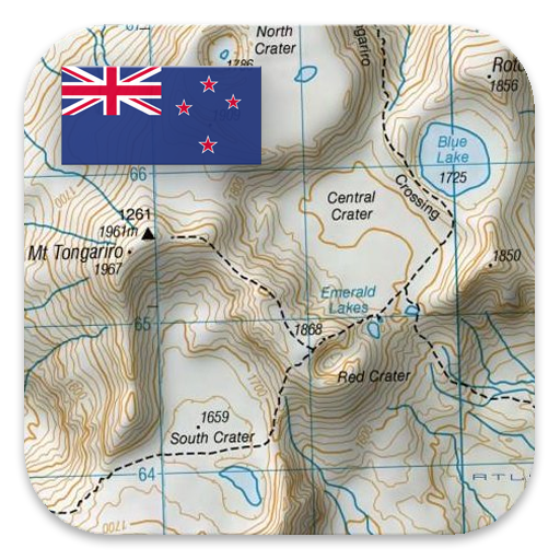
The topographic maps were created by Land Information New Zealand (LINZ).
Topo50 is the official topographic map series used by New Zealand emergency services.
How topographic information is used
Defence planning: New Zealand's defence forces use topographic information for planning military exercises and swapping information with international partners.
Location and routing: Search and Rescue, defence, ambulance, fire service, police and civil defence agencies use topographic information in a wide range of planning and operational situations, from natural disasters to community policing. Usage may involve mobile/field and control room situations, and the combination of topographic information with other data.
Land management: Topographic information is used by local government for regional planning and operations, and by power, gas and telecommunications companies.
In addition, LINZ maps are used for a great variety of purposes by businesses and government departments such as the Department of Conservation, and by recreational users such as trampers and tourists.
All topographic maps have additional labels for better readability at higher zoom scales. Maps are rendered with Atlogis® hillshading to enhance topography.
Topo Map Coverage:
New Zealand and Islands (Antipodes, Auckland, Bounty, Campbell, Chatham, Kermadec, Raoul, Snares and Stewart Islands) at scale 1:50.000 and 1:250.000
Cook Islands (Aitutaki, Atiu, Mangaia, Manihiki, Mauke, Mitiaro, Palmerston, Penrhyn, Pukapuka, Rakahanga, Rarotonga, Suwarrow, Takute) at scale 1:25.000
Tokelau Islands (Atafu, Nukunonu, Fakaofo) at scale 1:25.000
Please send comments and feature requests to nzmaps@atlogis.com
Introduction
New Zealand Topo Maps is a comprehensive topographic mapping application designed to provide detailed geographical information for the entire country of New Zealand. It combines high-resolution topographic maps with a range of advanced features, making it an indispensable tool for outdoor enthusiasts, hikers, and anyone interested in exploring the diverse landscapes of New Zealand.
Features
* High-Resolution Topographic Maps: The app features seamless topographic maps covering the entire country, with zoom levels ranging from 1:25,000 to 1:250,000. These maps provide accurate and detailed information on terrain, elevation, contour lines, rivers, lakes, roads, and other geographic features.
* Offline Accessibility: All maps can be downloaded and stored offline, allowing users to access them even in remote areas without an internet connection. This ensures reliable navigation and information retrieval in all situations.
* GPS Tracking and Navigation: The app integrates with GPS devices to provide real-time location tracking and navigation capabilities. Users can record their tracks, mark waypoints, and follow pre-defined routes or create their own.
* Elevation Profiles: The app generates elevation profiles along any route, providing insights into the terrain and elevation changes along the path. This information is essential for planning hikes, bike rides, or other outdoor activities.
* Slope Angle Measurement: Users can measure slope angles at any point on the map, helping them assess the steepness of terrain and make informed decisions about route selection.
* Search and Waypoint Management: The app includes a powerful search function to quickly find locations, points of interest, and specific features on the map. Users can also create and manage waypoints, marking important locations for future reference.
* Customizable Basemaps: New Zealand Topo Maps offers a variety of customizable basemaps, including topographic, satellite, and hybrid views. Users can choose the basemap that best suits their needs and preferences.
* Offline Routing: The app allows users to calculate routes and generate turn-by-turn directions even when offline. This ensures uninterrupted navigation and route planning in areas with limited or no internet connectivity.
Benefits
* Enhanced Outdoor Navigation: New Zealand Topo Maps provides accurate and detailed topographic information, enabling users to navigate confidently in unfamiliar or challenging terrain.
* Comprehensive Planning and Preparation: The app allows users to plan and prepare for outdoor activities by studying elevation profiles, measuring slope angles, and identifying key landmarks.
* Safety and Convenience: Offline accessibility and GPS tracking features enhance safety and convenience, ensuring that users can navigate safely and access information even in remote areas.
* Exploration and Discovery: The app encourages exploration and discovery by providing detailed maps of New Zealand's diverse landscapes, from towering mountains to pristine coastlines.
Conclusion
New Zealand Topo Maps is an essential tool for anyone exploring the diverse landscapes of New Zealand. Its high-resolution topographic maps, advanced features, and offline capabilities make it an invaluable companion for hikers, outdoor enthusiasts, and anyone seeking detailed geographic information about the country.
Information
Version
7.4.1
Release date
Aug 03 2024
File size
40 MB
Category
Maps&Navigation
Requires Android
7.1+ (Nougat)
Developer
XplrNZ.com
Installs
0
ID
com.atlogis.nzmaps.free
Available on