

Download Area Calculator For Land APK (209) for Android for free. Measure real estate, focus on area, perimeter, distance of plots and farmland
Area Calculator For Land
Download apk
(8.52 MB)
Screenshot
Description
Content
Measure real estate, focus on area, perimeter, distance of plots and farmland
The best tool for calculator field, perimeter, or area meter on a map: easy to use and useful for estimating the dimension of land on the map includes :
- Use the latest GPS and location service technical for a good assessment result
- Easy to search for the desired place
- Process of metrology to output is a land dimension of field, estimate distance of a route
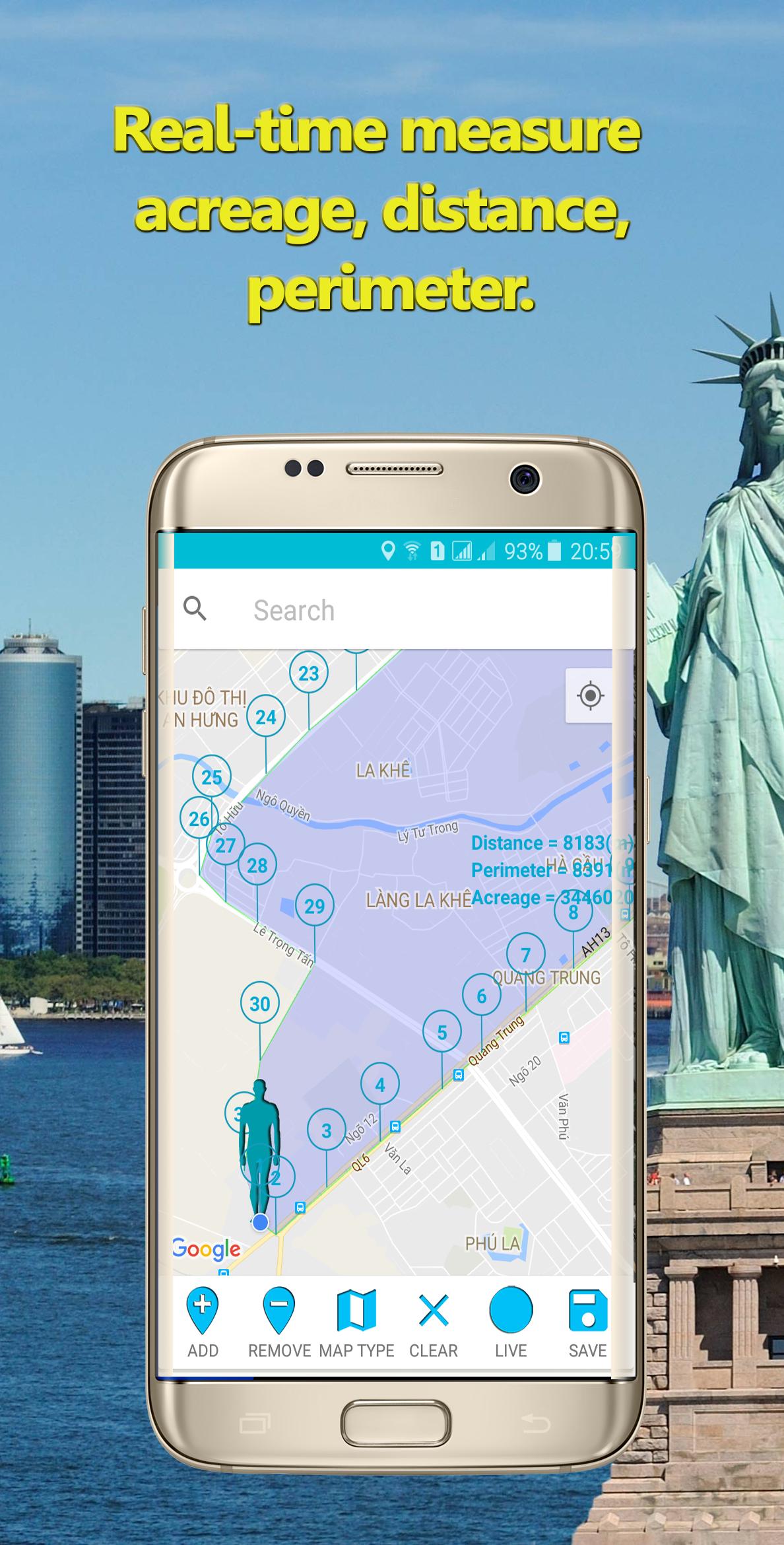
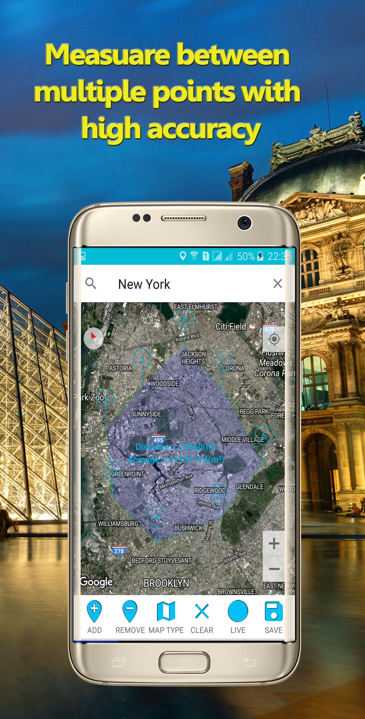
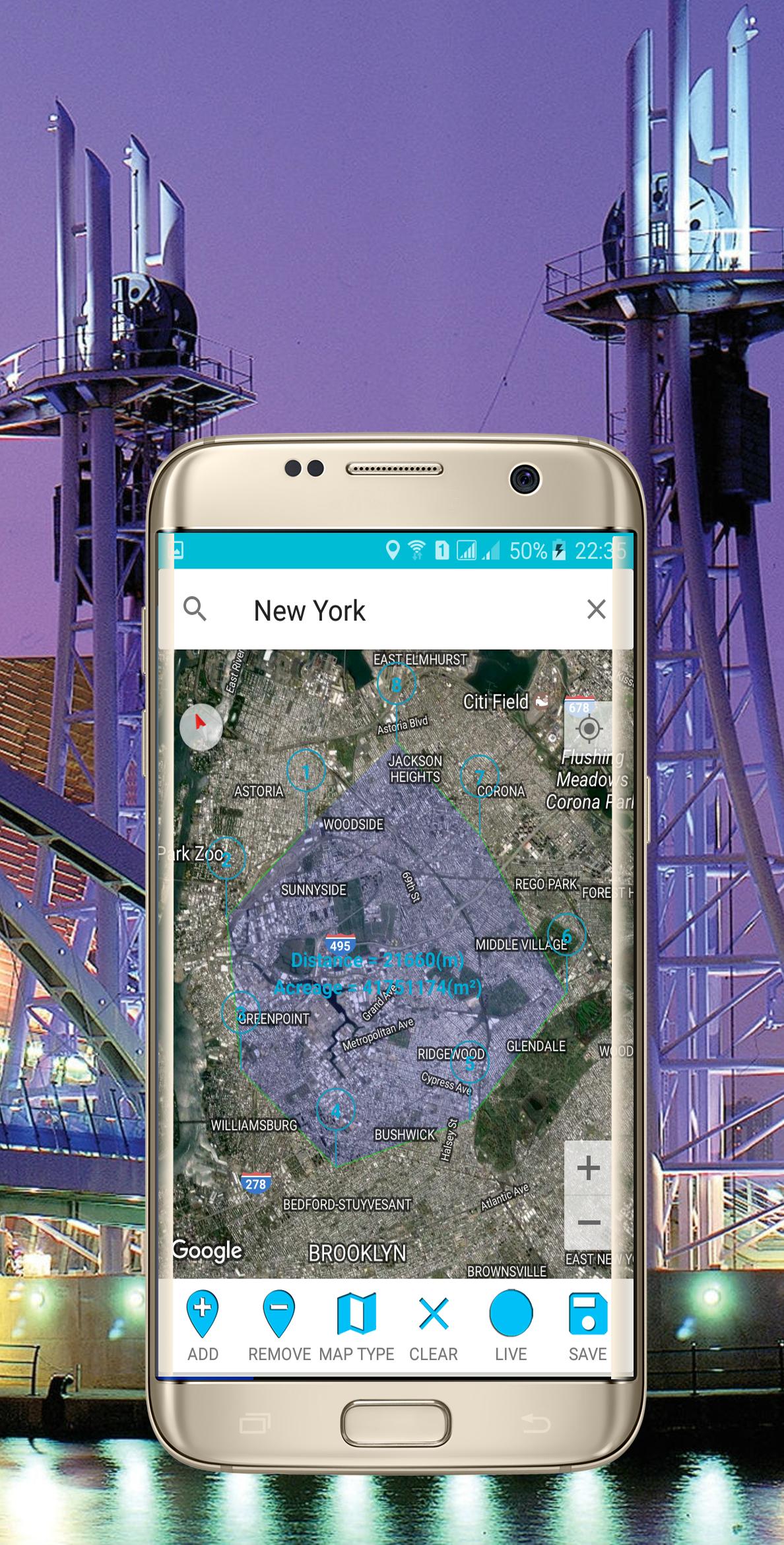
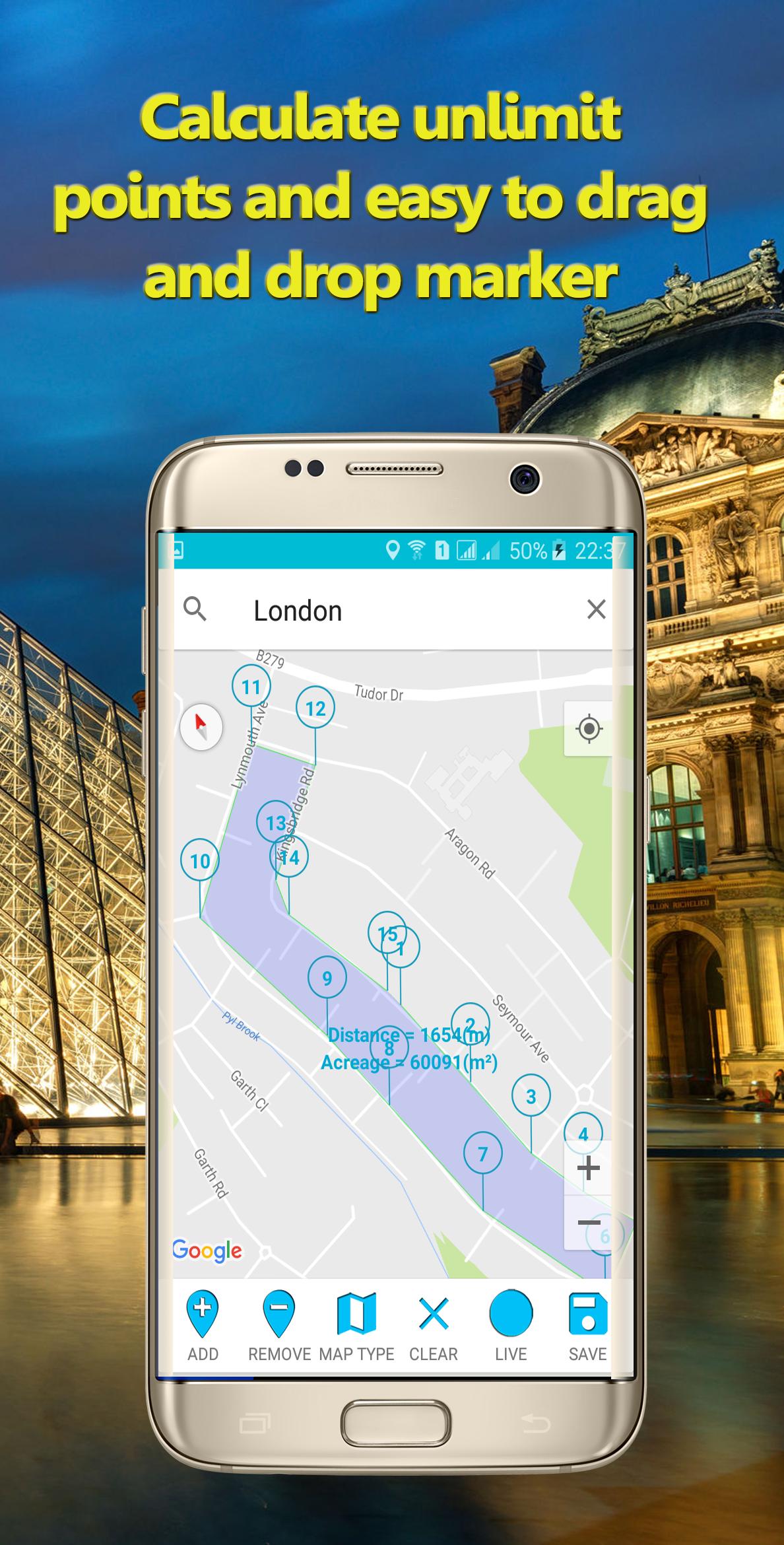
- Define the outline of a field on the ground by clicking on the map then calculate superficies, circumferential, and distances around your region
- Measure perimeter instant, estimate perimeter to calculate outside of region, area, or even country
- Details of an outer edge between points selected on the screen
- Proximate distance and far distance, estimate distance with high computation accuracy
- Land metrology, measuring fields for a farmer, calculating acreage on a map
- Realtime tracking and calculating when moving in orbit around
- It is a ground meter tool and meterage for map
- Compute on the map with high accuracy fast and reliable
- Easy way to drag and drop location or point on the ground by clicking on a marker.
- Able to resize area and custom area
- Save your area calculation in detail and easy to inspect each measure dimension
- Live tracking your route when you go every day
- The measuring unit is flexible for choice
- It is a land survey for anyone
How to use :
- Click on an add point icon then click on a map to create a point base on latitude and longitude
- Define the multiple marker points for calculation, the information of area include marker, polyline, polygons, and calculation result appear immediately
- Select the map type icon to change between types: none, normal, hybrid, terrain, and satellite type to look visually
- Click on a remove icon then click on a desired marker to remove it from out map.
- Touch on a clear icon to clear all markers, polygons, and polylines on the map
- When you want to real-time measurement you just click on a live icon and then move around to take effect.
- Then after getting everything you need and you want to save the current working, you click on the save icon to save it on the cache for re-use purposes.
- Click on a polyline to have a mini-tour around points
Area calculator for land applies material design to improve user experience.
Application is useful for geologists and farmers or simply anyone uses for route tracking every day
If you would like to see this app translated into your language, please email us. Technical Note:
- GPS and location services based on the latest location technical.
The accuracy of location is relying on Network Connection and GPS mode.
- If the accuracy is too low app will ignore the result, so please double-check when you see the point
random change big enough then make sure GPS is in High Accuracy mode,
Network Connection or Mobile connection on and Location permission enable.
Disclaimer:
Area Calculator For Land uses Google Maps™ and Google location service to measure so the position and place rely on the accuracy of the data provided by Google Maps™ developer makes no assurance on the accuracy, relevancy, or correctness of the data provided by the application.
Google™ and Google Maps™ have registered trademarks of Google Inc.
Support and Feedback:
If you have any technical problems please email us at
Please include all information about the problems and attach a screenshot if possible.
The more information that you provide to us, the better we can try to serve you and crush any bugs that may exist.
We are always ready to hear every idea from you, then try our best effort to make the app of top quality.
- Facebook :
https://www.facebook.com/Area-Calculator-For-Land-Perimeter-and-Field-108007074317220/
- Youtube :
https://www.youtube.com/channel/UCPfi4XeYX6MF6wQ84JbBVPA/
- Website :
https://clstudio.info/
What's New in the Latest Version 209
Last updated on Jun 20, 2024
- Best Area Calculator For Land
- Fix Bug : Crash
Area Calculator For Land is a mobile application designed to assist users in calculating the area of land parcels using various methods, including GPS tracking, manual input of coordinates, and importing shapefiles. The app offers a user-friendly interface and a range of features to enhance the accuracy and efficiency of land area calculations.
Key Features:
* GPS Tracking: Users can utilize the app's GPS tracking feature to trace the boundaries of a land parcel and automatically calculate its area. This method is ideal for measuring irregular or inaccessible land parcels.
* Manual Coordinate Input: For precise measurements, users can manually input the coordinates of the land parcel's vertices. The app supports various coordinate systems, including latitude and longitude, UTM, and MGRS.
* Shapefile Import: Users can import shapefiles, which are digital representations of land parcels, into the app. This feature allows for quick and accurate area calculations of complex land parcels with intricate boundaries.
* Area Measurement Units: The app provides a range of area measurement units, including acres, hectares, square meters, and square feet. Users can select the desired unit based on their preferences or the requirements of their project.
* Save and Share Results: Calculated area measurements can be saved within the app for future reference or shared with others via email, messaging, or cloud storage services.
Benefits of Using Area Calculator For Land:
* Accuracy and Precision: The app employs advanced algorithms and utilizes high-resolution data to ensure accurate and precise area calculations.
* Convenience and Time-Saving: GPS tracking and shapefile import features streamline the measurement process, saving users time and effort compared to traditional methods.
* Data Management: The app provides a centralized platform for storing and managing land area calculations, eliminating the need for manual records or spreadsheets.
* Improved Decision-Making: Accurate land area measurements are crucial for informed decision-making in land acquisition, property development, and agricultural planning.
* Professionalism: The app presents a professional and standardized approach to land area calculations, enhancing the credibility of measurements and reports.
Target Users:
Area Calculator For Land is designed for a wide range of users, including:
* Landowners and farmers
* Real estate professionals
* Surveyors and engineers
* Landscape architects and urban planners
* Government agencies and non-profit organizations involved in land management and conservation
Information
Version
209
Release date
Jun 20 2024
File size
8.52 MB
Category
Maps&Navigation
Requires Android
Android 6.0+
Developer
Đəv Ğàmiţ
Installs
5M+
ID
com.location.calculate.areas
Available on