

Download BRouter APK (1.7.6) for Android for free. Configurable, (bike-) Router for OFFLINE Navigation, based on open data.
BRouter
Download APK
(3.08 MB)
Screenshot
Description
Content
Configurable, (bike-) Router for OFFLINE Navigation, based on open data.
Configurable, elevation-aware (bike-) Router for OFFLINE Navigation based on open data. Works in conjunction with a Map Application.
See http://brouter.de/brouter for more documenation
See http://brouter.de/brouter-web for an online version.
*** If you do not know one of the supporting map applications, then the BRouter-App is useless for you. Download only if you are willing to spend some time to understand the setup. No one-star reviews from the unpatient please! email for problems ***
BRouter does only the plain route-calculation and does not display a map or the calculated route on it's own and therefore works only together with a Map Application. There are two different methods for the interfacing between BRouter and the Map application: BRouter offers a service interface that is called by the map application without a need to start the BRouter-App. This way, BRouter is a routing service very much like an online routing service, including dynamic recalculations if you get off the track. The other mode of operation is to start the BRouter-App and use waypoints from the map application's waypoint database to define your route. The calculated route is then written as a GPX file (including the elevation profile) to the map-application's tracks directory.
Some popular map apps support both the service interface and the interface via the wayoint database in their current versions available on Google Play.
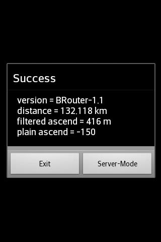
The service interface uses a timeout of 60s, limiting it's use to distances of about 50km, but using the BRouter App you are able to calculate much longer distances. But even long-distance tracks can be followed via the service interface (including dynamic recalculations). This is done by pre-calculating a route for your destination once using the BRouter App and assigning it to a routing mode via the "Server-Mode" Button. This feature is called "timeout-free recalculations".
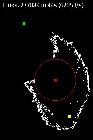
The route calculation, no matter if via the service interface or via the BRouter App, also considers nogo areas that can be defined as waypoints with a special naming convention (e.g. "nogo200" for 200m radius). This way it is possible to account for actual obstacles, but this feature can also be used to enforce personal preferences.
BRouter contains a download manager that assists downloading the required routing data files.The download manager is called on the first start of the app, and later on it is offered if internet access is available.
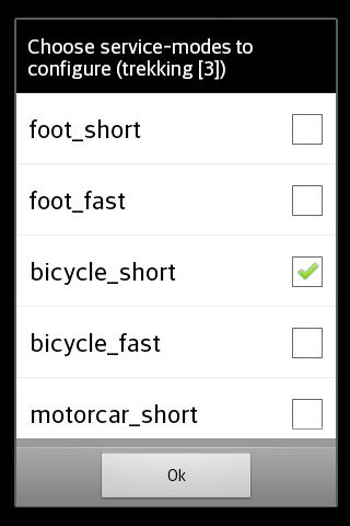
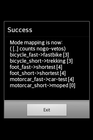
The mapping from one of the 6 routing modes (car/bike/foot * fast/short), that are used traditionally by routing services, and BRouter's concept of fully configurable routing profiles get's the following default mapping after the installation of BRouter:
car-fast -> car-test
car-short -> moped
bike-fast -> fastbike
bike-short -> trekking
foot-fast -> shortest
foot-short -> shortest
This mapping, however, can by changed anytime via the "Server-Mode" Button of the BRouter App. But also the routing profile definitions can be changed or new ones can be created.
Routing for cars is is currently available only in an experimental state ("car-test") and is not recommend. For example, turn-restriction are not taken into account.
What's New in the Latest Version 1.7.6
Last updated on Jun 21, 2024
bug fix for car profiles
BRouter: A Comprehensive Routing and Navigation ApplicationBRouter is an open-source routing and navigation application specifically designed for cyclists, hikers, and other outdoor enthusiasts. It offers a comprehensive suite of features that cater to the unique needs of these activities, providing detailed route planning, turn-by-turn navigation, and a wealth of relevant information.
Advanced Routing Capabilities
BRouter's core strength lies in its sophisticated routing engine, which takes into account various factors such as terrain type, elevation gain, traffic conditions, and user preferences. It supports multiple routing modes, including road cycling, mountain biking, hiking, and wheelchair accessibility, ensuring optimal routes tailored to the user's activity.
Detailed Map Data
The application utilizes high-quality map data from OpenStreetMap (OSM), providing accurate and up-to-date information on roads, trails, and other geographical features. Users can also import custom maps or create their own, giving them the flexibility to explore unfamiliar areas with confidence.
Turn-by-Turn Navigation
BRouter provides clear and concise turn-by-turn navigation instructions, both visually and through voice prompts. The navigation interface is intuitive and easy to follow, even in challenging outdoor environments. It also includes a heads-up display (HUD) mode, which projects navigation information onto the user's smartphone screen for quick and convenient reference.
Extensive Points of Interest
The application includes a comprehensive database of points of interest (POIs) relevant to outdoor activities, such as campsites, water sources, bike shops, and scenic viewpoints. Users can search for POIs by category or proximity, making it easy to plan stops and discover new places along their routes.
Elevation Profiles and Gradient Analysis
BRouter provides detailed elevation profiles for planned routes, allowing users to visualize the terrain they will encounter. The application also calculates the average gradient and maximum slope for each route, helping cyclists and hikers assess the physical demands of their journey.
Route Sharing and Collaboration
BRouter allows users to easily share their routes with others through various platforms, including social media and email. This feature fosters collaboration and enables users to explore new areas recommended by friends or fellow outdoor enthusiasts.
Offline Functionality
The application supports offline functionality, allowing users to download map data and routes for use in areas with limited or no internet connectivity. This feature ensures uninterrupted navigation even in remote locations.
Customizable Interface
BRouter offers a customizable interface, allowing users to tailor the application to their specific preferences. They can adjust the map style, change the navigation settings, and configure various other options to enhance their user experience.
Active Development and Community Support
BRouter is an actively developed project with a dedicated team of contributors. The community provides ongoing support through forums and online documentation, ensuring that users have access to the latest updates and resources.
Information
Version
1.7.6
Release date
Jun 21 2024
File size
3.08 MB
Category
Maps&Navigation
Requires Android
Android 4.0+
Developer
Ma V Dương
Installs
100K+
ID
btools.routingapp
Available on
