)
)
)
)
)
)
)
)
Download GPS Location Satellite Maps APK (4.8) for Android for free. GPS Location Navigation with Satellite view of your location and search places.

GPS Location Satellite Maps
Download APK
(8.1 MB)
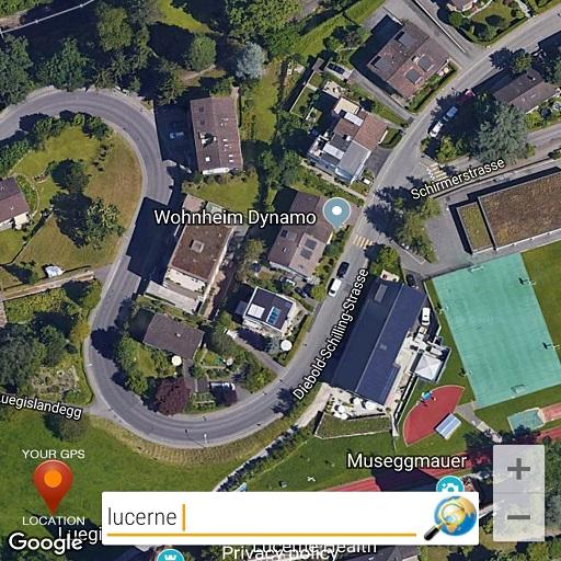
Screenshot
Description
Content
GPS Location Navigation with Satellite view of your location and search places.
Get your GPS Location and Search for destination and places and view them in satellite maps. Get your location & surroundings for easy navigation while driving and standing.
What's New in the Latest Version 4.8
Last updated on Jun 21, 2024
Minor bug fixes and improvements. Install or update to the newest version to check it out!
GPS Location Satellite Maps: A Comprehensive GuideIntroduction
GPS Location Satellite Maps is a mobile application that leverages the Global Positioning System (GPS) and satellite technology to provide users with real-time location tracking, navigation, and mapping services. It empowers users to explore their surroundings, plan journeys, and navigate efficiently.
Features
* Real-Time Location Tracking: The app accurately tracks the user's current location using GPS technology, displaying it on a detailed map.
* Navigation and Routing: Users can enter destinations and receive turn-by-turn voice-guided navigation, optimizing their routes based on traffic conditions and road closures.
* Offline Maps: The app allows users to download maps for offline use, ensuring seamless navigation even without an internet connection.
* Satellite Imagery: The app provides access to high-resolution satellite imagery, enabling users to view detailed aerial perspectives of their surroundings.
* Street View: Users can explore streets and landmarks in 360-degree panoramic views, providing a realistic virtual experience.
* Live Traffic Updates: The app displays real-time traffic information, including congestion, accidents, and road closures, helping users avoid delays.
* Speed Limit Alerts: The app warns users when they exceed the speed limit, promoting road safety and compliance.
* Point of Interest Search: Users can search for nearby businesses, attractions, restaurants, and other points of interest, along with their contact information and directions.
* Share Location: The app allows users to easily share their current location with others via messaging or social media platforms.
Benefits
* Enhanced Navigation: The app provides precise and efficient navigation, reducing the risk of getting lost or taking unnecessary detours.
* Time-Saving: By optimizing routes and providing real-time traffic updates, the app helps users save time on their journeys.
* Improved Safety: Speed limit alerts and location sharing features promote road safety and peace of mind.
* Convenience: The app's offline maps and user-friendly interface make it convenient to use even in remote areas or with limited internet connectivity.
* Exploration and Discovery: The app encourages users to explore their surroundings, discover new places, and appreciate the world around them.
Compatibility and Pricing
GPS Location Satellite Maps is compatible with Android and iOS devices. It offers both a free version with limited features and a premium subscription that unlocks advanced functionalities. The premium subscription includes ad-free navigation, unlimited offline map downloads, and additional features.
Conclusion
GPS Location Satellite Maps is a comprehensive and user-friendly app that empowers users with real-time location tracking, navigation, and mapping services. Its wide range of features and benefits make it an indispensable tool for travelers, commuters, and anyone seeking to enhance their mobility experience.
Information
Version
4.8
Release date
Jun 21 2024
File size
8.1 MB
Category
Maps&Navigation
Requires Android
Android 5.0+
Developer
Suheb Mzmer
Installs
5M+
ID
com.avenueinfotech.locationmaps
Available on