


Download Live Earth Satellite maps 3D APK (1.9.0) for Android for free. Explore Earth with satellite maps, find routes to travel with Satellite maps 360
Live Earth Satellite maps 3D
Download XAPK
(18.2 MB)
Screenshot
Description
Content
Explore Earth with satellite maps, find routes to travel with Satellite maps 360
Explore the earth with Satellite maps and earth globe in world map and also see street view in live earth map. Use satellite finder to track the satellites Position in Space. You can see planet earth on the map with 2d solar system to See and get detailed info about the planets. Enjoy route tracker to find routes and travel throughout the Earth. View live streaming of different places of Earth.
The Live earth satellite map provide you world maps , GPS map camera, route tracker and navigation on the globe. In navigation you can use route finder, GPS map, Globe map to enjoy navigation feature on earth map. And also advance feature like NASA Galaxy view, Elevation meter, Live street view and compass.
In find Ai Destination the app select place of your interest by only answering a few questions and you can enjoy your tour and enjoy 3d maps. With live earth cam you can explore places in street attractions to explore places in live earth globe. Watch weather of upcoming days in weather forecast module. Also you can see the every country code in the Satellite view Earth Globe Map. Calculate your age in age calculator and enjoy from FM radio. The app provide you 3d maps, earth cams, and street view to enjoy the world map and satellite earth map.
The Satellite view Earth Globe Map provide live earth cams, street view maps, 3d earth maps and world map clock. The app provide all function that you need in the live earth map and GPS location on the world map. Sitting in home and enjoy earthcams and satellite view in earth map. Enjoy the view of earth cam live app. You can visit any place virtually through Satellite view Earth Globe Map and enjoy the features of earth map like earth cams street view, navigation, route tracker, route finder and also 2d solar system.
The key features of the app is:
• Live Earth Map:
Explore the world at your fingertips! Dive into real-time satellite views, 360° panoramas, and street-level exploration with our Live Earth Map app
• GPS Map Camera:
Capture any place with its latitude and longitude on live earth map.
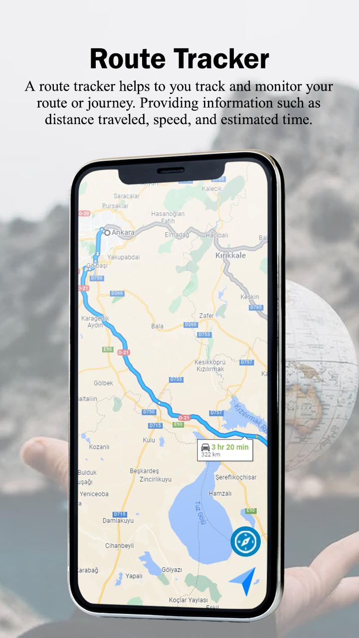
• Route Tracker:
Track your destination with route tracker to enjoy travel in your daily basis tour.
Enjoy the route tracker and save the tracks in your phone. Let’s you keep history of your
Routes
2. Navigation:
• Route Finder:
Navigate yourself to any place on earth with Gps navigation
• GPS time:
Set GPS time from world clock and check all clocks around the world.
Set your GPS time for your selected place.
• Globe Map:
Enjoy globe map know about countries details in the earth map.
Take live earth quiz to enhance brain next level.
3. Advanced:
• NASA Galaxy View:
Enjoy astronomy picture in Satellite view Earth Globe Map.
• Elevation Meter:
The elevation meter provide altitude of your current location.
• Live Street Views:
Watch 360 view of street view of all places in the world.
• Compass:
The compass provide live direction in Satellite view Earth Globe Map.
4. Find AI Destination:
The AI Destination provide your interest base location for traveling around the world and explore earth map. You can select country, categories of your interest and the app provide the location of your interest base and the details of the place.
You can also save the world map location of your travel journey
5. 2D Solar System:
2D solar system lets you explore planets in space. Explore planet earth and 3d planets in Satellite view Earth Globe Map.
6. Area Calculator:
Measure area from area calculator with GPS maps location in the world.
7. Satellite Tracker:
Track any Satellite with satellite finder to get details of every Satellite in the app.
8. Street Attractions:
In street view you can view tourist attractions of famous places in the world in earth map. And also view from the earthcams of each and every country.
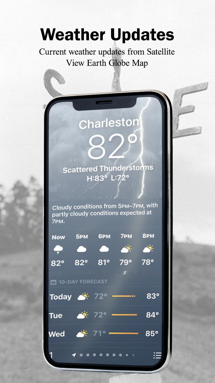
9. Weather:
Get updates of the latest weather forecast in the world.
10. FM Radio:
Enjoy FM Radio channels of every countries in the world map
What's New in the Latest Version 1.9.0
Last updated on May 28, 2024
Fixed Crashes and Issues
Live Earth Satellite Maps 3DOverview
Live Earth Satellite Maps 3D is a captivating mobile application that offers a comprehensive and interactive experience of our planet from the perspective of a satellite. With its high-resolution satellite imagery and intuitive navigation, the app empowers users to explore the Earth's diverse landscapes, landmarks, and weather patterns in real-time.
Key Features
* Real-Time Satellite Imagery: Live Earth Satellite Maps 3D provides access to real-time satellite images, ensuring that users can observe the Earth's surface as it changes dynamically.
* 3D Globe View: The app features a stunning 3D globe view that allows users to zoom in and out, rotate the globe, and tilt it for a comprehensive perspective of the planet.
* Global Weather Maps: Live Earth Satellite Maps 3D includes real-time weather maps that provide up-to-date information on temperature, precipitation, cloud cover, and wind patterns.
* Landmark Exploration: The app features a database of thousands of landmarks, allowing users to explore iconic locations around the world with detailed descriptions and images.
* Street View Integration: Live Earth Satellite Maps 3D integrates with Google Street View, enabling users to virtually explore cities and towns at street level.
User Interface and Navigation
Live Earth Satellite Maps 3D boasts a user-friendly interface that makes it easy for users to navigate and explore the app's features. The intuitive controls allow for seamless panning, zooming, and rotating of the globe, providing an immersive experience.
Educational Value
Live Earth Satellite Maps 3D serves as an invaluable educational tool for students, educators, and anyone interested in geography and the Earth sciences. The app's real-time satellite imagery and comprehensive weather maps provide a unique opportunity to study the Earth's diverse ecosystems, weather patterns, and environmental changes.
Conclusion
Live Earth Satellite Maps 3D is an exceptional mobile application that combines real-time satellite imagery, interactive navigation, and educational value. With its stunning 3D globe view, global weather maps, landmark exploration, and Street View integration, the app offers a captivating and informative experience for users of all ages.
Information
Version
1.9.0
Release date
Jun 10 2024
File size
18.2 MB
Category
Travel&Local
Requires Android
Android 8.0+
Developer
미미
Installs
1M+
ID
com.earthmap.location.tracker.shareaddress.routefinder
Available on