Download Swiss Topo Maps APK (7.3.0) for Android for free. Easy-to-use GPS navigation app with maps and aerial images for Switzerland.
Swiss Topo Maps
Download APK
(20.1 MB)
Screenshot
Description
Content
Easy-to-use GPS navigation app with maps and aerial images for Switzerland.
New App. Introductory price - only for a short time.
Easy-to-use outdoor GPS navigation app with the best topographical maps and aerial images for Switzerland.
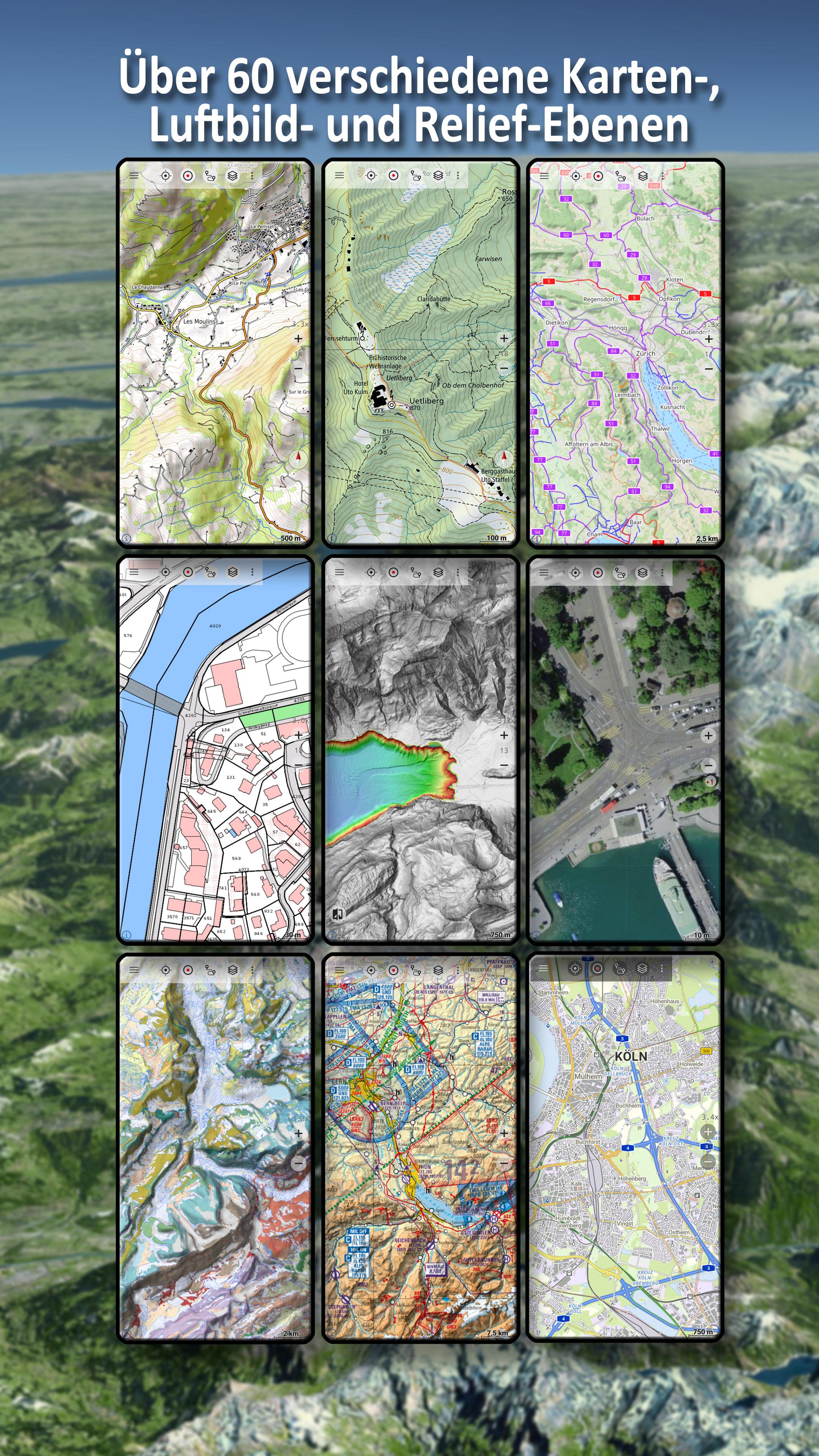
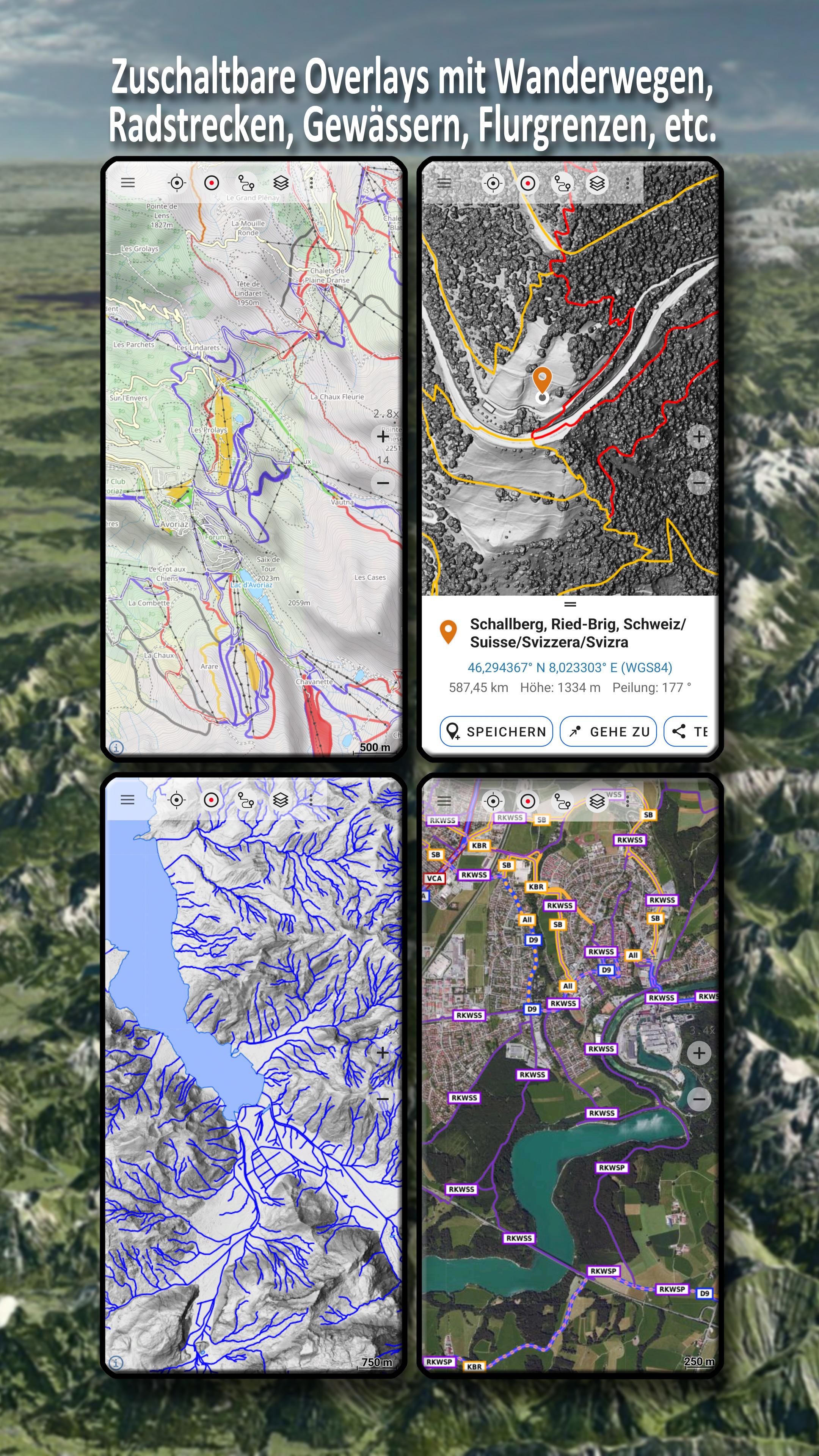
Over 60 different map types for Switzerland. Plus 13 map layers with worldwide coverage and numerous overlays such as hiking or cycling trails.
In addition to the worldwide OpenStreetMap (OSM) maps in various styles, you have access to the detailed official swisstopo maps from the Federal Office of Topography of Switzerland.
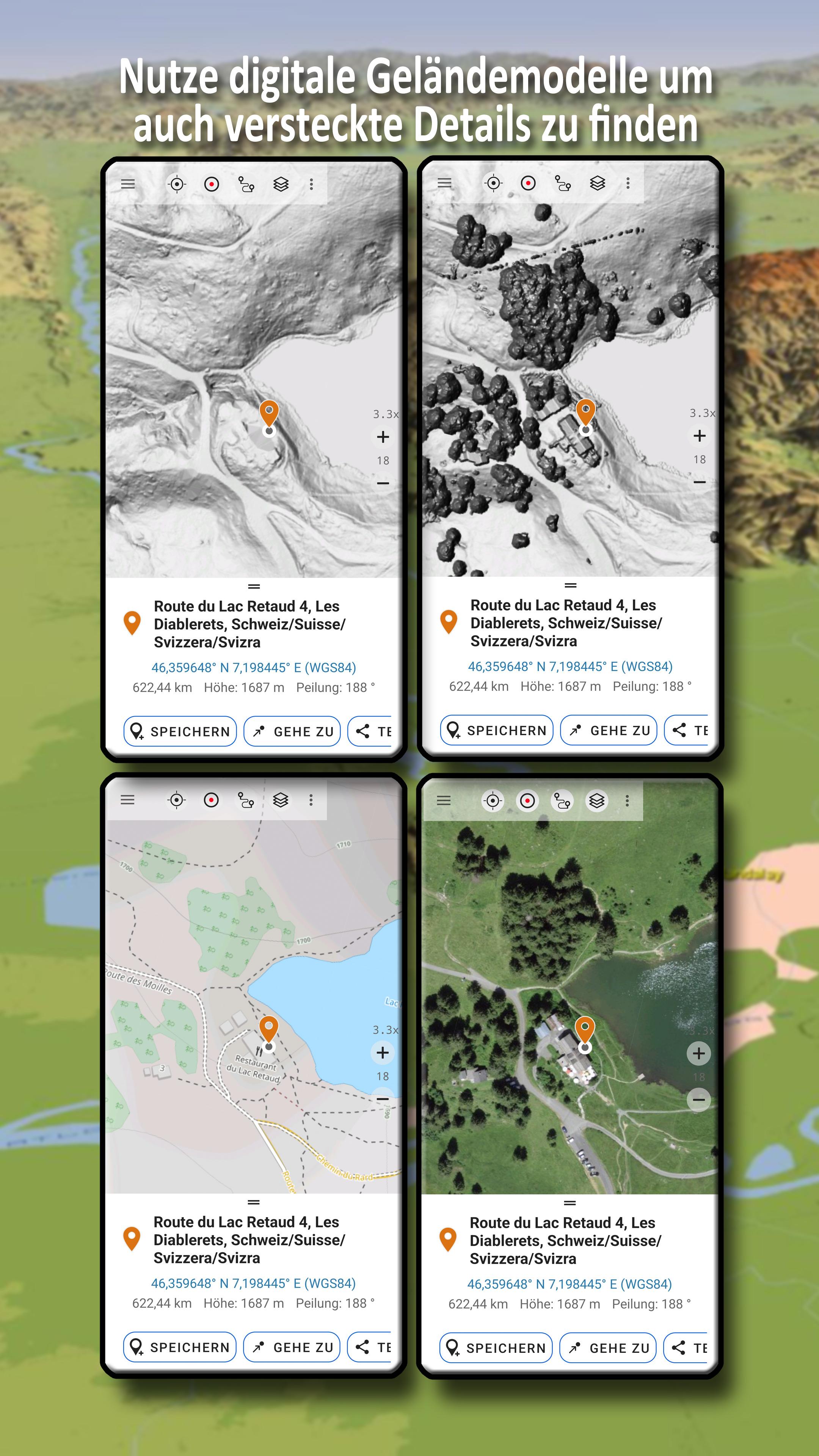
There are hiking maps, cycling maps, aerial imagery, geological maps, digital terrain models, aeronautical maps and historical maps for the whole of Switzerland.
There are also numerous switchable overlays such as hiking and cycling trails, river network, contour lines and shading.
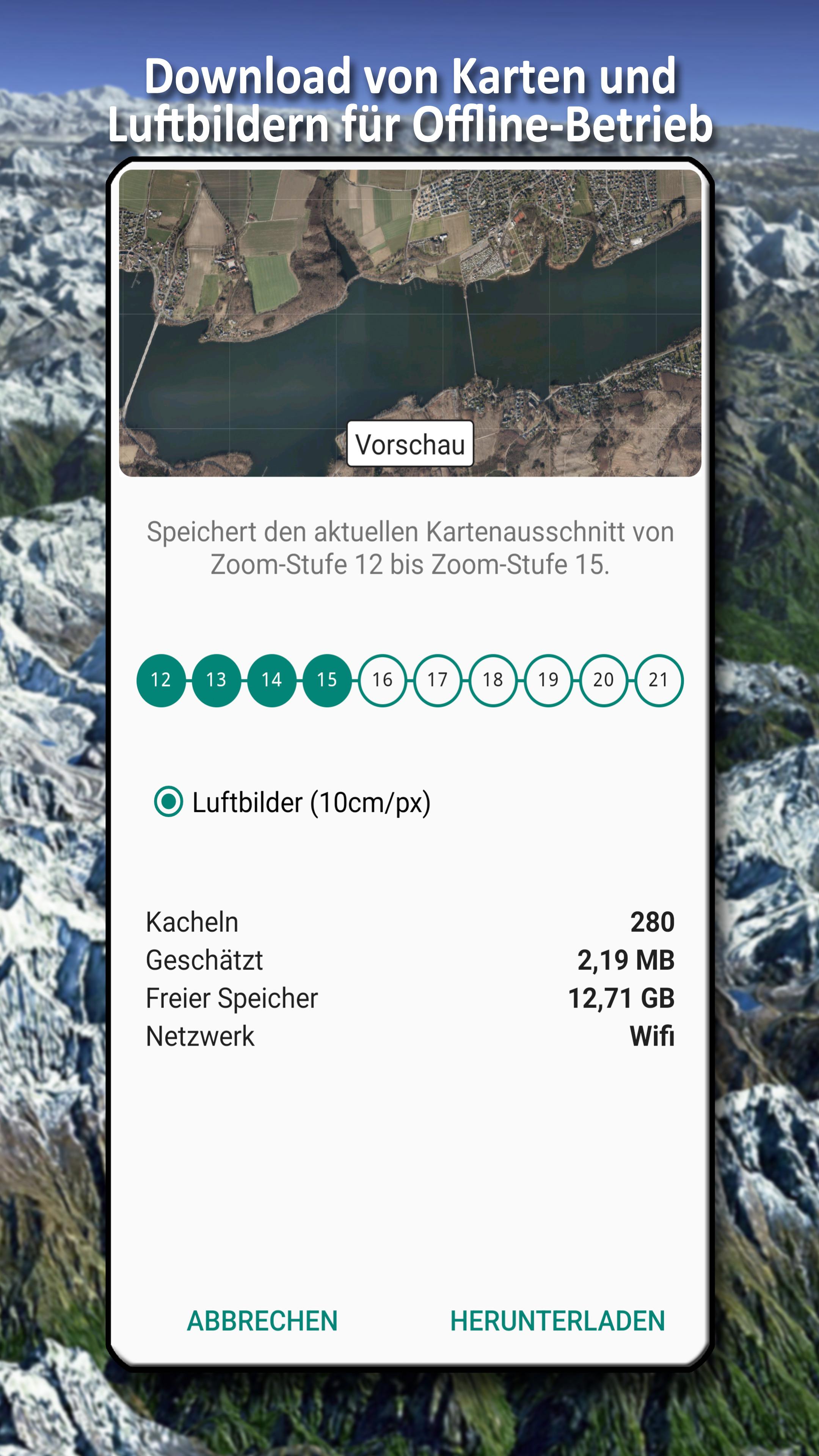
Maps and aerial photographs can be downloaded free of charge for defined regions so that you do not need an Internet connection when travelling.
There are also map layers from other commercial map providers such as Google, ESRI or Bing (these are only available online).
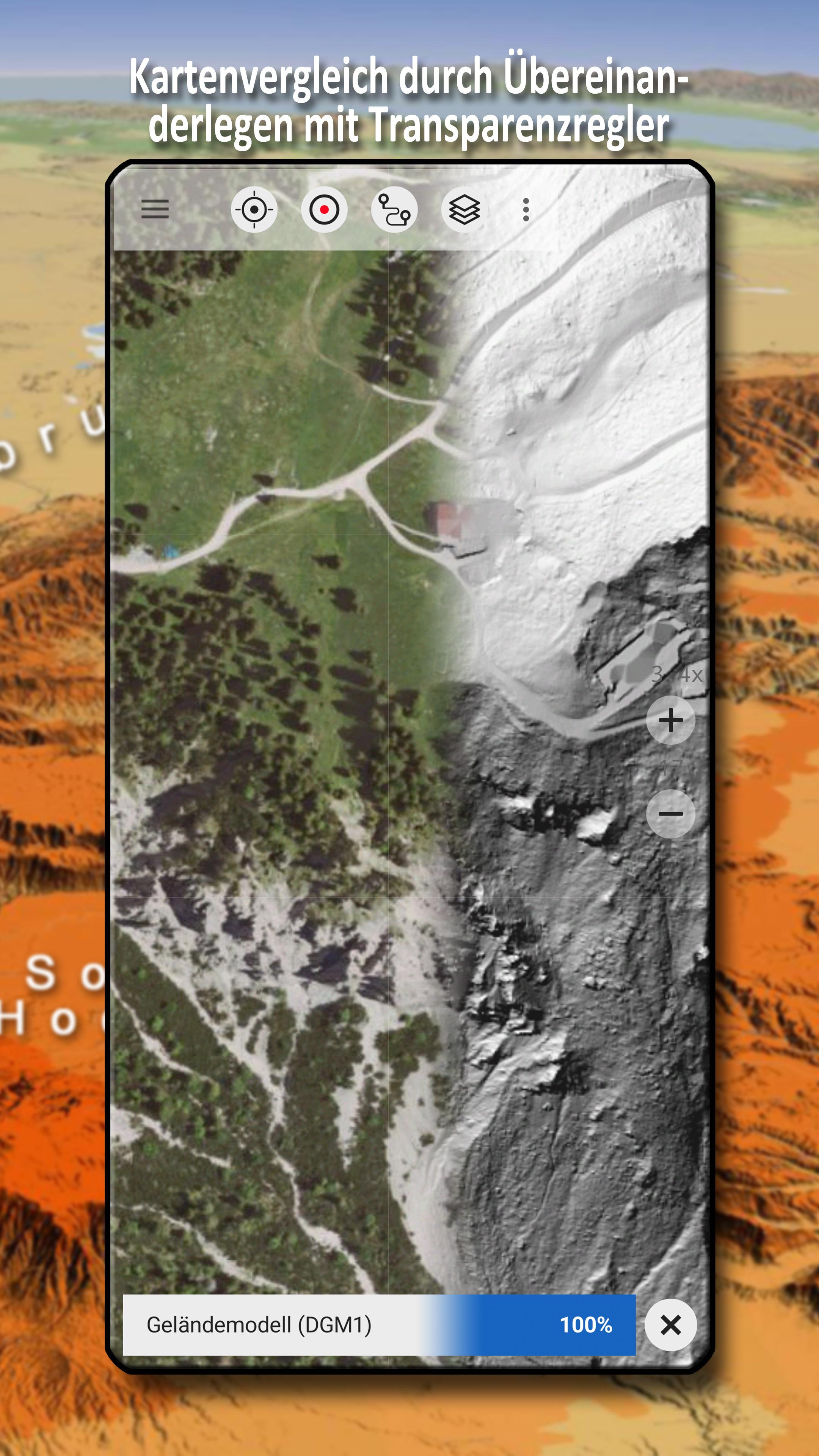
All maps can be added as an overlay and compared using a transparency slider.
There is no such thing as the perfect map - so you can use this app to decide which map is best suited to your purpose and region.
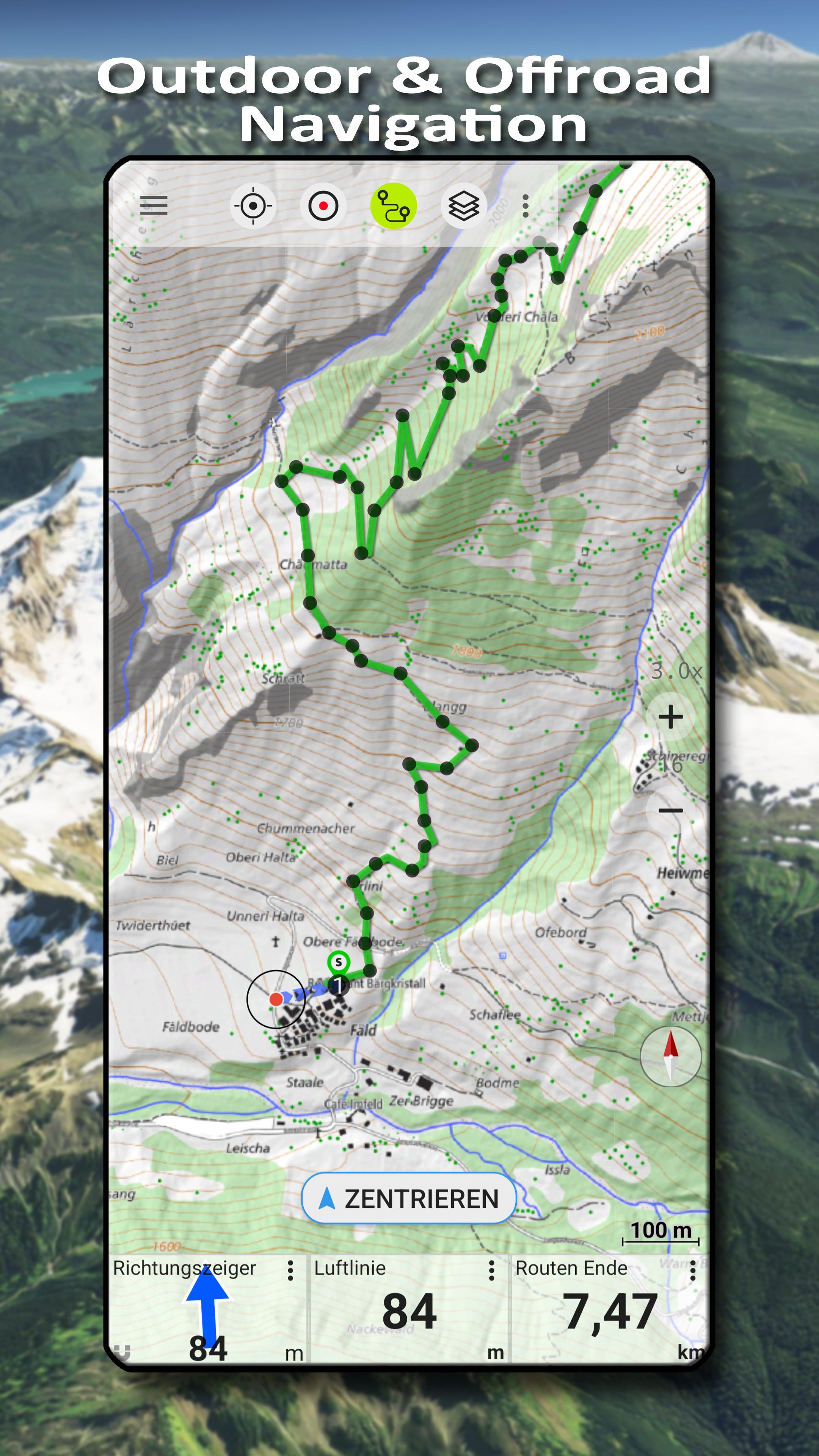
The most important functions for outdoor navigation:
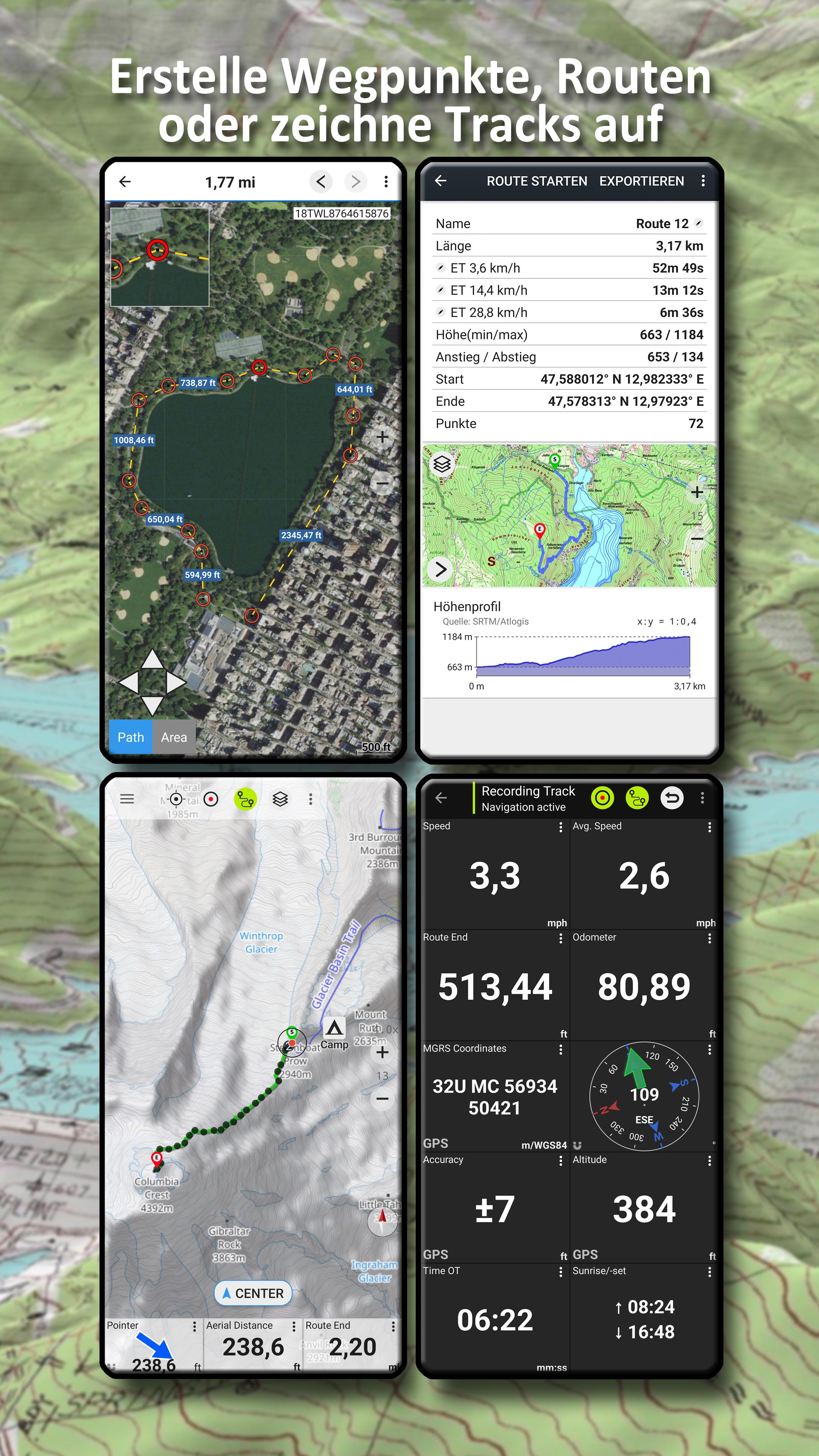
- Creating and editing waypoints
- GoTo waypoint navigation
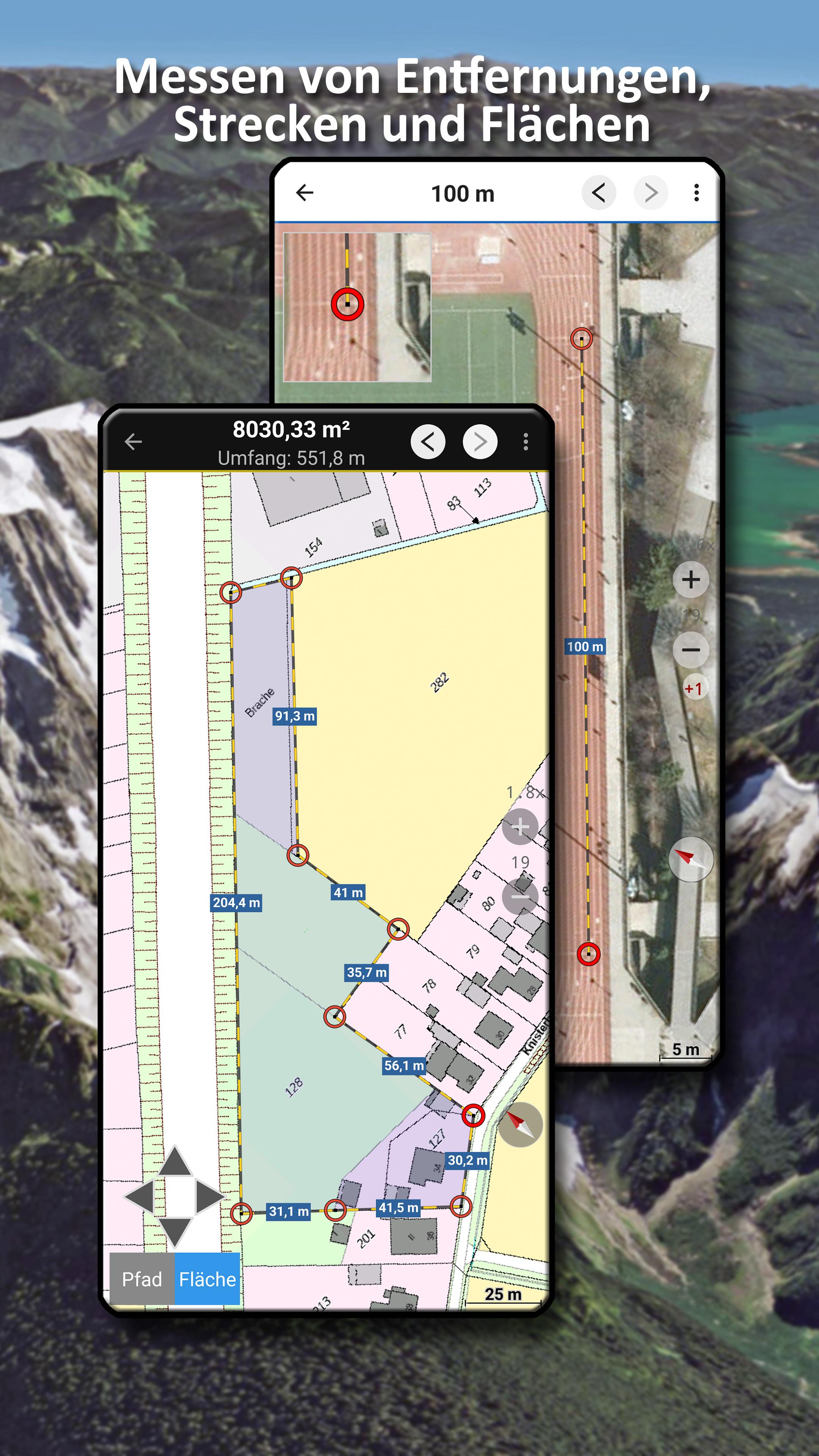
- Measuring routes and areas
- Tripmaster with data fields for daily kilometres, average speed, bearing, altitude, etc.
- Search (place names, streets)
- Definable data fields in map view (e.g. arrow, distance, compass, ...)
- Sharing of waypoints, tracks or routes (via eMail, Whatsapp, Dropbox, Facebook, ...)
- Use of coordinates in WGS84, UTM or MGRS
- Record & share tracks with statistics & elevation profile
- Display of altitude and distance by long click on map
- ...
Additional Pro functions:
- Offline use without data connection
- Easy download of map data for OFFLINE use (except Google & Bing)
- Create and edit routes
- Route navigation (point-to-point navigation)
- GPX/KML/KMZ import/export
- Unlimited waypoints & tracks
- Add new Tile Servers, WMS map services, MBTiles
- No advertising
Map layer for Switzerland:
- Topographic national maps (1:10,000 - 1:1,000,000)
- Swiss TLM
- National Map Winter
- SwissImage Aerial image
- SwissALTI3D terrain model
- Surface model swissSURFACE3D
- Aeronautical chart ICAO
- Glider map
- Geological map 1:25,000 & 1:500,000
- Historical maps
Switchable overlays Switzerland:
- Hiking trails
- Wanderland/Veloland/Mountainbikeland/Skatingland
- Ski routes & snowshoeing
- Water network
- Infrastructure
- Protected areas
- CadastralWebMap
Map layer world:
- OpenStreetMaps : These collaboratively created maps are a very good supplement to the official maps and in some cases also more detailed
- OSM Outdoors: OpenStreetMap data focussing on hiking trails, shading and contour lines
- OpenCycleMaps: OpenStreetMap data with a focus on cycle paths
- ESRI Topographic, Aerial & Street
- Google Road, Satellite & Terrain Map (only with online connection)
- Bing Road & Satellite Map (only with online connection)
- Various overlays such as cycling and hiking trails, shading or bodies of water
Please send questions and feature requests to
What's New in the Latest Version 7.3.0
Last updated on Jun 20, 2024
・Fixes
Swiss Topo MapsSwiss Topo Maps is a comprehensive and detailed set of topographic maps covering the entire territory of Switzerland. These maps are renowned for their accuracy, reliability, and exceptional level of detail, making them an indispensable tool for hikers, climbers, mountaineers, and anyone else interested in exploring the Swiss Alps and beyond.
Key Features
* Extensive Coverage: Swiss Topo Maps cover the entire Swiss Confederation, including the Alps, the Jura Mountains, and the Swiss Plateau.
* Multiple Scales: The maps are available in various scales, ranging from 1:10,000 to 1:500,000, providing users with the flexibility to choose the appropriate level of detail for their specific needs.
* High Accuracy: Swiss Topo Maps are meticulously surveyed and updated regularly, ensuring their accuracy and reliability.
* Detailed Information: The maps include a wealth of information, such as contour lines, elevations, trails, roads, water bodies, and other geographic features.
* Clear and Concise Design: The maps are designed with clarity and readability in mind, making it easy to navigate and locate points of interest.
Applications
Swiss Topo Maps have a wide range of applications, including:
* Hiking and Mountaineering: These maps are essential for planning and navigating hiking and mountaineering routes in the Swiss Alps. They provide detailed information on trails, elevation profiles, and potential hazards.
* Climbing and Ski Touring: Climbers and ski tourers rely on Swiss Topo Maps to assess routes, locate access points, and identify potential risks.
* Orienteering: Swiss Topo Maps are widely used in orienteering competitions, providing participants with precise and reliable navigation tools.
* Research and Planning: Geographers, geologists, and other researchers utilize Swiss Topo Maps to study the physical characteristics of the Swiss landscape and plan projects accordingly.
Availability
Swiss Topo Maps are available in both printed and digital formats. Printed maps can be purchased from bookstores, tourist information centers, and online retailers. Digital maps are available for download from the Swiss Federal Office of Topography (swisstopo).
Conclusion
Swiss Topo Maps are an invaluable resource for anyone interested in exploring the Swiss Alps and beyond. Their accuracy, detail, and wide range of applications make them indispensable tools for hikers, climbers, mountaineers, and researchers alike.
Information
Version
7.3.0
Release date
Jun 20 2024
File size
20.1 MB
Category
Maps&Navigation
Requires Android
Android 5.0+
Developer
Nihad Ibrahim
Installs
1K+
ID
com.atlogis.swiss
Available on